File:Santa Fe Trail map.gif

Original file (993 × 589 pixels, file size: 43 KB, MIME type: image/gif, 0.2 s)
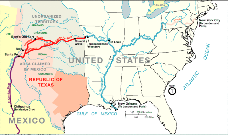
Description: Santa Fe Trail around 1845 from Santa Fe, New Mexico to western Missouri, with connecting trade routes, such as El Camino Real de Tierra Adentro trail from Chihuahua to Santa Fe, the Missouri River, the Mississippi River, Ohio River, and Pennsylvania canals, with ports and hubs.
Drawn by: NPS-graphics (U.S. National Park Service).
Date: about 2005?
Source: "File:1845 trailmap.gif" in "Santa Fe Trail" in Wikipedia: the Free Encyclopedia at http://en.wikipedia.org/wiki/Santa_Fe_Trail (accessed 19 July 2009) citing http://www.nps.gov/beol/trailmap.gif.
Permission: Public domain. This image or media file contains material based on a work of a National Park Service employee, created during the course of the person's official duties. As a work of the U.S. federal government, such work is in the public domain. See the NPS website and NPS copyright policy for more information.
File history
Click on a date/time to view the file as it appeared at that time.
| Date/Time | Thumbnail | Dimensions | User | Comment | |
|---|---|---|---|---|---|
| current | ★ Approved revision 13:49, 19 July 2009 | | 993 × 589 (43 KB) | DiltsGD (talk | contribs) | '''Description:''' Santa Fe Trail around 1845 from Santa Fe, New Mexico to western Missouri, with connecting trade routes, such as El Camino Real de Tierra Adentro trail from Chihuahua to Santa Fe, the Mississippi River, Ohio Rivers, and Pennsylvania cana |
You cannot overwrite this file.
File usage
The following page uses this file: